Tamil Nadu FMB Sketch Online – View Field Measurements and Plot Boundaries
Land survey records are important when you want to understand the recorded measurements, shape and boundaries of a property. In Tamil Nadu, one of the key survey-related records used for this purpose is the FMB Sketch, or Field Measurement Book Sketch.
An FMB sketch provides graphical and measurement-related information for a surveyed land parcel. It can be particularly useful when checking a Survey Number, Subdivision Number, field measurements and the relative position of plot boundaries.
Tamil Nadu has digitized many land and survey records, making it easier for citizens to access available information online. Depending on the service and area, users can check land-related records using a mobile phone or computer.
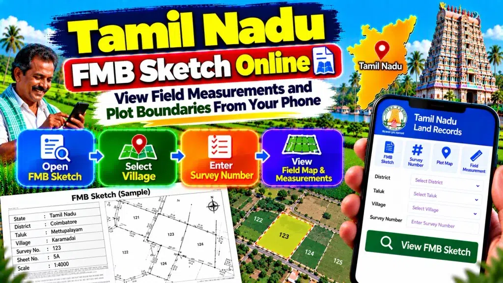
This guide explains Tamil Nadu FMB Sketch Online, what an FMB contains, how to view field measurements and plot boundaries, and how to compare an FMB sketch with Patta/Chitta and A-Register records.
Tamil Nadu FMB Sketch – Quick Overview
| Details | Information |
|---|---|
| State | Tamil Nadu |
| Record | FMB Sketch |
| Full Form | Field Measurement Book |
| Record Type | Survey / Measurement Record |
| Main Reference | Survey Number |
| Additional Reference | Subdivision Number |
| Main Purpose | View field measurements and parcel sketch |
| Plot Shape | Can be represented |
| Recorded Boundaries | Can be represented |
| Related Revenue Record | Patta / Chitta |
| Related Village Record | A-Register |
| Search Location | District, Taluk and Village |
| Mobile Access | Available through applicable digital services |
| Physical Boundary Verification | May require official survey |
| Best Use | Understanding recorded parcel measurements |
What Is a Tamil Nadu FMB Sketch?
FMB stands for Field Measurement Book. It is an important survey record associated with individual land parcels.
Unlike a basic textual revenue record, an FMB sketch provides graphical information about surveyed land.
It can represent the parcel’s recorded shape, measurements and boundaries according to the available survey record.
The FMB is therefore useful when you want to understand how a particular Survey Number or Subdivision Number is represented in official survey information.
It can also be compared with your Patta, A-Register and registered property documents.
Why Is an FMB Sketch Important?
Property documents often contain Survey and Subdivision Numbers, but those numbers alone may not help an ordinary user visualize the parcel.
An FMB sketch adds spatial context.
For example, it may help you understand the shape of a parcel and the measurements recorded for its sides or sections.
This can be useful when reviewing land before purchase, checking a subdivision, comparing old and current documents or preparing for an official survey.
However, FMB information should always be interpreted together with the correct property and revenue records.
What Details Can an FMB Sketch Show?
An FMB sketch can contain measurement and survey information connected with a parcel.
Depending on the applicable survey record, you may find the Survey Number and Subdivision reference along with the graphical layout of the land.
Measurements associated with the surveyed parcel can also appear.
The sketch can help show the relationship between the selected parcel and its recorded boundaries.
Exact details can vary according to the survey record, so users should not expect every FMB sketch to look identical.
What Is a Survey Number?
A Survey Number is an important identifier used for surveyed land in Tamil Nadu.
It connects a land parcel with the applicable survey and revenue records.
The Survey Number may appear in your registered deed, Patta, A-Register and other property documents.
When checking an FMB, always use the Survey Number together with the correct District, Taluk and Village.
A Survey Number without its location context is not sufficient for reliable property identification.
What Is a Subdivision Number?
A Survey Number can be divided into smaller parcels.
The Subdivision Number identifies the specific portion created or recorded within the larger Survey Number.
This becomes especially important where only a part of a larger parcel has been sold, partitioned or separately recorded.
If your property has a Subdivision Number, make sure you use the complete reference when checking the FMB.
Searching only the main Survey Number may lead you to information covering a larger area than your individual parcel.
How to Check Tamil Nadu FMB Sketch Online
Begin with the applicable official Tamil Nadu land-record or survey service.
Select the relevant option for FMB or survey information.
Choose the correct District.
Select the Taluk where the property is located.
Choose the Village.
Enter or select the correct Survey Number.
Select the applicable Subdivision Number where required.
Complete any verification shown by the current service.
Review the available FMB or survey information.
Because government interfaces can change, always follow the current fields displayed by the official service.
How to View FMB From Your Mobile
Many land-record searches can now be performed using a smartphone.
Before starting, keep your Patta, deed or another reliable property document nearby.
Confirm the District, Taluk, Village, Survey Number and Subdivision Number.
Use these details to identify the correct parcel.
Once the FMB sketch is available, zoom in carefully to examine the measurements and parcel layout.
A larger screen can make detailed survey sketches easier to read, but a mobile phone is useful for an initial check.
How to Read an FMB Sketch
An FMB sketch can appear complicated if you have never used survey records before.
Start with the Survey and Subdivision references.
Identify the outline of the relevant parcel.
Review the measurements displayed around or within the parcel.
Compare the shape and measurements with your property documents.
Do not assume that every line visible on the sketch represents a wall, fence or other physical feature currently visible on the land.
The FMB represents survey information and should be interpreted in that context.
Can FMB Show Plot Boundaries?
An FMB sketch can show the recorded survey boundaries of a parcel.
This is one of the main reasons people search for FMB information.
The sketch can help you understand how a parcel is represented in the survey record and how its sides relate to surrounding land.
However, there is an important distinction between a boundary shown in a survey record and the exact boundary physically identified on the ground.
Where the boundary is disputed, an official survey or demarcation may be necessary.
FMB Sketch vs Patta/Chitta
An FMB Sketch and Patta/Chitta serve different purposes.
Patta/Chitta primarily provides textual revenue and landholding information.
FMB focuses on survey measurements and graphical parcel information.
For example, Patta information can help identify the applicable recorded landholding, while the FMB helps provide measurement and spatial context for the Survey/Subdivision parcel.
For better verification, compare both records rather than relying only on one.
FMB Sketch vs A-Register
The A-Register is another important Tamil Nadu revenue record.
It provides survey-based textual information such as applicable parcel references, land extent and classification.
The FMB provides the graphical and measurement side of survey information.
If you are checking a property, the A-Register can help confirm the Survey Number, Subdivision, area and classification, while the FMB can help you understand the recorded parcel layout.
Together, they provide different but complementary information.
How to Check Land Measurements
First identify the correct Survey and Subdivision Numbers.
Open the applicable FMB sketch.
Locate the intended parcel.
Review the measurements shown in the survey record.
Compare those details with the land extent recorded in the A-Register, Patta and registered deed.
If several subdivisions exist under the same Survey Number, make sure you are reviewing the measurement for the correct subdivision.
For important measurements, professional or official survey assistance may be appropriate.
What If the FMB and Patta Details Do Not Match?
First check whether all location and parcel references are correct.
Verify the District, Taluk, Village, Survey Number and Subdivision Number.
Compare the FMB with the latest Patta and A-Register.
Also review your registered deed.
A mismatch can sometimes involve subdivision, older survey information or a later record update.
If the discrepancy remains significant, approach the appropriate Revenue or Survey authority rather than attempting to determine the correct boundary from an online image alone.
FMB Sketch Before Buying Land
An FMB sketch can be useful during preliminary property verification.
Check the Survey and Subdivision Numbers mentioned in the seller’s documents.
Compare them with the Patta and A-Register.
Review the FMB sketch and recorded parcel measurements.
Check whether the land extent corresponds with the property documents.
Where boundaries are particularly important, consider an appropriate official survey before completing a major transaction.
FMB should form part of the verification process rather than being the only record examined.
Online FMB vs Physical Land Survey
An online FMB sketch provides recorded survey information.
A physical land survey involves identifying and measuring the parcel on the ground according to the applicable official process and records.
These should not be confused.
An online sketch can help you understand the parcel before visiting the property.
But if neighbouring owners disagree about a boundary or the physical markers are unclear, an official measurement or survey process may be needed.
Is an FMB Sketch Proof of Ownership?
An FMB sketch is primarily a survey and measurement record.
It should not be treated as standalone conclusive proof of legal ownership.
Ownership verification can require the registered deed, Patta, inheritance or succession documents, partition or gift deeds, court orders, encumbrance information and other applicable records.
The FMB is particularly valuable for understanding the surveyed parcel rather than independently establishing title.
Frequently Asked Questions (FAQ)
1. What is an FMB Sketch in Tamil Nadu?
FMB stands for Field Measurement Book. The sketch contains survey and measurement-related information about a land parcel.
2. Can I check Tamil Nadu FMB online?
Available FMB and survey information can be accessed through applicable official Tamil Nadu digital land-record services.
3. Can I view an FMB from my mobile?
Yes. Applicable digital land services can be accessed using a suitable smartphone or mobile browser.
4. Does an FMB show land measurements?
Yes, an FMB is used for survey and field-measurement information associated with the relevant parcel.
5. Does FMB show plot boundaries?
It can represent the recorded survey boundaries and shape of the applicable parcel.
6. What details do I need to find an FMB?
You should keep the District, Taluk, Village, Survey Number and applicable Subdivision Number ready.
7. Is FMB the same as Patta?
No. Patta is primarily a revenue/landholding record, while FMB provides survey and measurement information.
8. Is FMB the same as A-Register?
No. A-Register provides textual survey and revenue information, while FMB provides graphical measurement information.
9. Can FMB settle a boundary dispute?
An FMB is useful evidence for understanding survey records, but an official on-ground survey or demarcation may be required for a disputed boundary.
10. Does an FMB Sketch prove ownership?
No. It should be examined together with registered deeds and other applicable property and revenue records.
Conclusion
Tamil Nadu FMB Sketch Online provides a useful way to view field measurements and plot boundaries associated with surveyed land.
For an accurate search, identify the correct District, Taluk, Village, Survey Number and Subdivision Number. Review the parcel sketch and measurements and compare them with the Patta/Chitta, A-Register and registered property documents.
The FMB is particularly valuable for understanding the recorded shape and measurement of a land parcel. However, an online sketch should not automatically be treated as a precise physical demarcation on the ground.
If there is a serious boundary or measurement dispute, the appropriate official survey process may be required. By using the FMB together with current revenue records and property documents, landowners and buyers can obtain a clearer understanding of the surveyed land.